The working group of physical geography is responsible for theses with a varied thematic focus. In the following, individual proposals are presented sorted according to the different areas of investigation and topics. If necessary, please contact the listed contact persons.
If you already have your own ideas or concepts for theses, you are welcome to contact members of our working group.
Themenbereich Environmental Change in the Atlas Mountains
, Foto: A. Köhler")
Holocene summer temperature and biodiversity change recorded by Chironomidae in Western Mediterranean North Africa - Recent biodiversity change in Moroccan Atlas Lakes
Mountain ecosystems are sensitive to anthropogenic impacts including climatic changes, however for North Africa, the biodiversity of aquatic invertebrates in lakes is relatively unknown. Therefore, this project aims to use lake sediment cores and the invertebrate remains contained therein, to reconstruct recent biodiversity change in one or more Moroccan Atlas Mountain lakes. This project involves a month-long field campaign to Morocco in July 2023 in which the student will tour ~20 lakes and have the opportunity to assist in retrieving a ca.12,000-year long lake sediment core.
Ansprechpartner: Alexander Bolland
Holocene hydroclimatic change in Morocco: stable isotopes from ostracods
Field survey in summer 2023 to Morocco with core recovery (preferably as a master's thesis)
Ansprechpersonen: Christoph Zielhofer, Anne Köhler, Steffen Mischke
Holocene summer temperature and biodiversity change recorded by Chironomidae in Western Mediterranean North Africa - Moroccan training set for deuterium and d18O isotopes from fatty acids
Field survey in summer 2023 to Morocco with core recovery (preferably as a master's thesis) - in cooperation with the Historical Anthropospheres working group (Leipzig Lab)
Ansprechpersonen: Alexander Bolland, Roland Zech
Reconstructing humidity changes in the Moroccan Atlas using isotopes from fatty acids
Ansprechpersonen: Alexander Bolland, Roland Zech
Lake Tislit basic proxies; carbonates, XRF, particle size, TOC
Late Quaternary geomorphological and environmental response to rapid hydrological changes in the Atlas Mountains, Morocco - Field survey in summer 2023 to Morocco with core recovery (preferably as a BSc thesis)
Asnsprechpersonen: Christoph Zielhofer, Laura Bergmann, Birgit Schneider
Lake Tislit XRF scanning record
Late Quaternary geomorphological and environmental response to rapid hydrological changes in the Atlas Mountains, Morocco - Field survey in summer 2023 to Morocco with core recovery (preferably as a BSc thesis)
Ansprechpersonen: Christoph Zielhofer, Rik Tjallingii
Saharan dust provenances analyses
Late Quaternary geomorphological and environmental response to rapid hydrological changes in the Atlas Mountains, Morocco - Samples from existing Moroccan sediment cores. Analysis radiogenic isotopes at MPI Chemistry in Mainz
Ansprechpersonen: Christoph Zielhofer, Sylvain Pichat
Sidi Ali (UAV) drone survey
Late Quaternary geomorphological and environmental response to rapid hydrological changes in the Atlas Mountains, Morocco - Geoarchiological field survey in summer 2023 to Morocco (MSc or BSc thesis)
Ansprechpersonen: Christoph Zielhofer, Lukas Werther
Holocene Lake Tislit pollen record
Late Quaternary geomorphological and environmental response to rapid hydrological changes in the Atlas Mountains, Morocco - Core recovery in summer 2023 (MSc or BSc thesis)
Ansprechpersonen: Christoph Zielhofer, Will Fletcher
Themenbereich Mesolithic of the Stonehenge Area

Buried landscapes of the Avon Valley and the Mesolithic of the Stonehenge Area - Direct push applications in floodplains
Anreise nach Stonehenge Area einschließlich Direct-Push-Geländearbeiten zur stratigraphischen Rekonstruktion eines mesolithischen Siedlungsplatzes. Direct push ist ein Verfahren zur Sondierung des Oberflächennahen Untergrundes. Reisekosten können übernommen werden. Geländekampagne ist vom 24.4. bis zum 5.5.2023
Ansprechpersonen: Christoph Zielhofer, Ulrike Werban, Johannes Rabiger-Völlmer
Buried landscapes of the Avon Valley and the Mesolithic of the Stonehenge Area - Geophysical prospection of floodplains
Anreise nach Stonehenge Area einschließlich geophysikalischen Geländearbeiten (ERT) zur stratigraphischen Rekonstruktion einer Aue im Bereich eines mesolithischen Siedlungsplatzes. ERT ist ein Verfahren zur Sondierung des Oberflächennahen Untergrundes entlang von Transekten. Reisekosten können übernommen werden. Geländekampagne ist vom 24.4. bis zum 5.5.2023
Ansprechpersonen: Christoph Zielhofer, Ulrike Werban
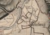
Themenbereich Fluvial & Historical Anthropospheres
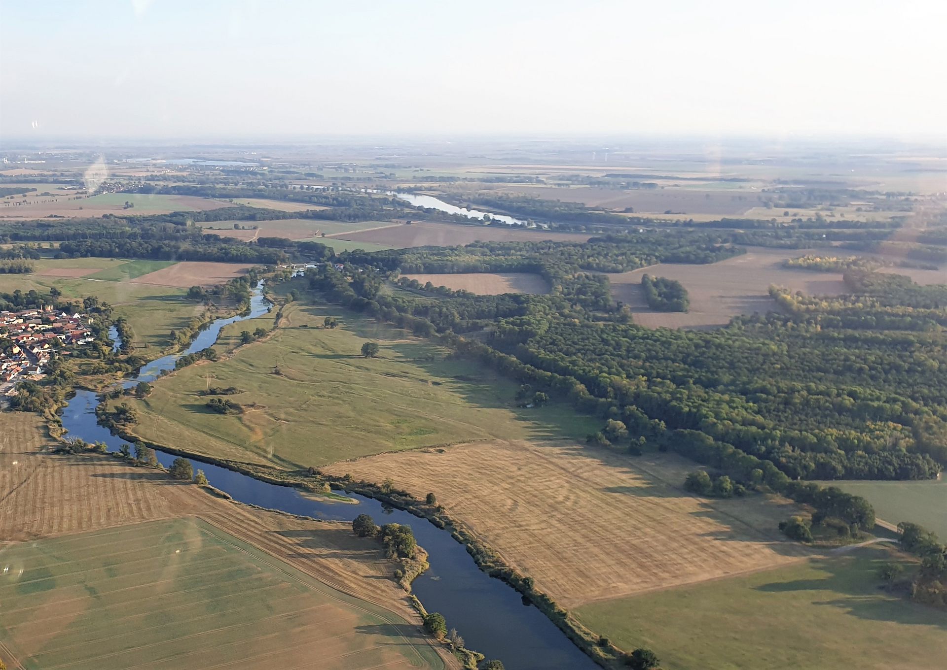
Leipzig, city in a state of flux - Fluvialgeomorphologie Leipziger Aue
Durchführung einer DGM-gestützten geomorphologischen Kartierung des Leipziger Auensystems. Abgleich mit einer zu referenzierenden Karte der Auenlehmmächtigkeiten und exemplarischer Ground Truth mittels Bohrungen im Gelände. Dies bildet die Grundlage für die Identifizierung geeigneter Positionen zur Rekonstruktion der fluvialen Dynamik in historischer Zeit.
Ansprechpersonen: Johannes Schmidt, Michael Hein
The Lower Havel River and Greater Donaumoos Regions: ‘Failed’ or ‘successful’ reclamation of floodplains and peatlands? - Fluvial geomorphology of the Lower Havel River
Implementation of a DTM-based geomorphological mapping of the Leipzig floodplain system. Comparison with a map of floodplain clay thicknesses to be referenced and exemplary ground truth using boreholes in the field. This will form the basis for identifying suitable positions for reconstructing fluvial dynamics in historic times.
Contact persons: Christoph Zielhofer, Anne Köhler
Reconstructing biodiversity and oxygen variability in a German lake (Mansfelder Land)
We could use invertebrate remains to reconstruct bottom O2 changes in a sediment core - in cooperation with the Historical Anthropospheres working group (Leipzig Lab)
Ansprechperson: Alexander Bolland
Quantitative analysis of historical maps in the Parthe catchment area
On the Way to the Fluvial Anthropsphere - Leipzig, city in a state of flux ‐ Urban‐fluvial symbiosis in a long‐term perspective
Ansprechpersonen: Christoph Zielhofer, Johannes Schmidt
Fluxgate magnetics prospection of investigation areas in Abtnauendorfer Park for the reconstruction of old river courses as well as geoarchaeological structures
On the Way to the Fluvial Anthropsphere - Leipzig, city in a state of flux ‐ Urban‐fluvial symbiosis in a long‐term perspective -Terrain survey of fluxgate magnetics data in the area of Abtauendorf Park
Ansprechpersonen: Johannes Schmidt, Johannes Rabiger-Völlmer, Andreas Stele
Geomorphological mapping in the Parthe catchment area
On the Way to the Fluvial Anthropsphere - Leipzig, city in a state of flux ‐ Urban‐fluvial symbiosis in a long‐term perspective
Ansprechpersonen: Johannes Schmidt, Michael Hein
Paleosurface modeling of the Parthe floodplain with regard to flood dynamics in a historical context
On the Way to the Fluvial Anthropsphere - Leipzig, city in a state of flux ‐ Urban‐fluvial symbiosis in a long‐term perspective
Ansprechpersonen: Johannes Schmidt, Bas van der Meulen
Diachronic mapping of archaeological structures in the Leipzig area
On the Way to the Fluvial Anthropsphere - Leipzig, city in a state of flux ‐ Urban‐fluvial symbiosis in a long‐term perspective - also suitable for students in the subject archaeology
Ansprechpersonen: Johannes Schmidt, Christian Tinapp, Harald Stäuble, Matthias Hardt
Construction of spatial databases on heavy metal contents of surface samples for Brandenburg (Elbe-Havel estuary), Saxony-Anhalt (Süßer See), or Bavaria ( Donau)
Question Brandenburg: The Havel-Elbe estuary is an interesting area, because waters and sediments in suspension "slosh" into the Havel area during flood events.
Question Bavaria: The Donau is fed by several large tributaries, both by water and sediments. The heavy metal contents allow the differentiation of the geological units. The floodplain sediments (e.g. near Straubing) are the sum of the input sediments and their geochemical composition. The precise spatial evaluation of the different catchments ultimately allows a different activation of the northern and southern tributaries in the floodplains. In perspective, coupling the surface samples with a Holocene floodplain archive may allow diachronic evolution of geomorphodynamic activity.
Contact persons: Dr. Johannes Schmidt and Prof. Dr. Christoph Zielhofer
Construction of a spatio-temporal database of published dates of colluvia and alluvia for Central Europe with the context of the respective sites (local EZG, relief parameters, settlement patterns, etc.)
Colluvia and alluvia are markers for geomorphodynamically active processes of erosion and sediment transport. In general, anthropogenic (e.g. deforestation, agriculture, etc.) and climatic influences (e.g. short-term climate change with altered precipitation distributions) are responsible. For many decades these sediment types have been described, studied and dated. Unfortunately, there is still a lack of a systematic compilation of these data. Such a compiled dataset allows both temporal and spatial analysis of the accumulations. The focus on spatio-temporal differences may help to better separate the triggering factors (anthropogenic vs. climate-induced).
Contact persons: Dr. Johannes Schmidt and Prof. Dr. Christoph Zielhofer
Reconstruction of fluvial systems with the help of historical maps
Floodplains are global hotspots of human intervention and highly sensitive socio-ecological mechanisms of action. They are particularly dynamic landscapes and core zones of cultural and natural heritage. Fluvial societies have radically and fundamentally altered central European floodplains because of their exceptionally high diversity and capacity for use and the associated strategies of land reclamation and risk mitigation. These changes can be reconstructed, among other things, with the help of historical maps. The aim of this work is to research and digitize historical maps in the study areas (Donaumoos, Untere Havel) and to map land use changes as well as changes in fluvial dynamics.
Contact persons: Christoph Zielhofer, Anne Köhler
Research and linking of previous geomorphological, archaeological as well as historical studies of the Danube terraces near Straubing
The Magdalen flood of 1342 is considered to be the millennium flood in Central Europe. There are individual studies dedicated to this topic in the Straubing area. However, there is a lack of interdisciplinary links. The aim of this thesis is to combine the case studies in order to generate a holistic picture of the effects of the flood.
Contact persons: Christoph Zielhofer, Anne Köhler
Visualization and GIS-based analysis of high-resolution DTMs
High-resolution digital terrain models (DTM) offer a very good possibility to quickly visualize elevation information of the landscape. However, many questions, especially in landscape reconstruction and the preservation of archaeological monuments, require adapted analyses on the DTM and an individual representation. This is to be realized on a section of the Danube with numerous oxbow lakes and Pleistocene as well as Holocene terrace levels in the area of Straubing. Especially against the background of current flood events, interested students can derive risk assessments in floodplain systems with the help of the digital terrain models.
Contact persons: Christoph Zielhofer, Anne Köhler
Evaluation of geophysical surface prospections (EMI) on the Danube at Straubing
Non-invasive geophysical prospections (electromagnetic induction, georadar, geoelectrics, etc.) allow a fast and large-scale near-surface site investigation. In cooperation with the UFZ Leipzig, previous results are to be evaluated and possible new sites at the oxbow lakes of the Danube near Straubing are to be investigated in more detail.
Contact persons: Christoph Zielhofer, Anne Köhler, Ulrike Werban
Themenbereich Weiße Elster

Luminescence dating of Holocene colluvia in the Zeitz loess hill country
Within the framework of the DFG project "Effects of Rapid Climate Changes and Human Activity on the Holocene Hydro-Sedimentary Dynamics of Central Europe (Model Region Loess-Covered White Elster Catchment)", which is running from 2017 to 2023, we are currently investigating Holocene colluvia, i.e. the correlative sediments of predominantly human-induced soil erosion, in a loess-covered small catchment south of Zeitz. In addition to the stratigraphic/sedimentological characterization of these sediments, they must also be chronologically classified in order to obtain information about past periods of intensive soil erosion. One method for this is luminescence dating, which dates the exposure of material during the last transport. To carry out this dating, we are looking for a bachelor's/master's student who is interested in carrying out this method, starting in autumn 2021. The work will start with sampling in the field, followed by sample preparation in the dark lab, analysis and age calculation, and placing the ages in a larger spatial and temporal context.
Contact: PD Dr. Hans von Suchodoletz


Sedimentological-pedological characterization of Holocene colluvia in the catchment area of the middle White Elster river
Within the framework of the DFG project "Impacts of Rapid Climate Changes and Human Activity on the Holocene Hydro-Sedimentary Dynamics of Central Europe (Model Region Loess-Covered White Elster Catchment)", running from 2017 to 2023, we are currently investigating Holocene colluvia, i.e. the correlative sediments of human-induced soil erosion, in two loess-covered small catchments south of Zeitz and south of Gera. Besides the chronostratigraphic classification, the sedimentological-pedological characteristics of these sediments have to be investigated. In this context, we will investigate to what extent the sedimentary properties of the colluvia deposited at different times differ from each other, or whether they are separated from each other by soil formations indicating longer geomorphologically stable periods without significant soil erosion. To carry out these investigations, we are looking for a bachelor's/master's student who is interested in conducting these analyses, starting in autumn 2021. The work will start with sampling in the field, followed by sample preparation and analysis in the geoecological laboratory and the classification of the results in a larger spatial and temporal context.
Contact: PD Dr. Hans von Suchodoletz


Analysis of surficial floodplain structures (river terraces, paleochannels, human constructions) in the uppermost floodplain of the Weiße Elster River
In a project currently being planned, the development of the floodplain of the upper White Elster (between Plauen and Adorf) since the Middle Ages is to be investigated. In this context, morphologically recognizable natural structures such as river terraces or paleochannels, as well as human constructions such as flood dams or canal systems connected to former mills or mining activities are to be systematically mapped by means of DEM analyses and subsequently classified with the help of historical maps. To carry out this research, we are looking for an immediate bachelor's/master's student who is interested in conducting these analyses. The thesis should be written in English.
Contact person: PD Dr. Hans von Suchodoletz


Themenbereich: Neandertaler im Norden
Landscape classification in the vicinity of Neanderthal sites in Lower Saxony
In the surroundings of established and prospected Middle Palaeolithic sites in Lower Saxony (Plönjeshausen, Lehringen, Salzgitter-Lebenstedt) a GIS-based landscape classification based on LIDAR-DGMs, thematic maps, excavation stratigraphies and drilling archives will be implemented. This forms the basis for the implementation of quaternary stratigraphic and archaeological measures, in which the candidate can also participate him/herself, if necessary.
Contact persons: Michael Hein
Stratigraphic prospection for an unknown Neanderthal site in Plönjeshausen (Nieders.)
In Plönjeshausen near Bremervörde (Nieders.) a Neanderthal site is suspected on the basis of surface finds. Detailed stratigraphic recordings of the soils and sediments from excavations and cores will help to better understand the former landscape and to localize the find layers. Field work will occur April 17-21, 2023, and laboratory analysis within the work is also possible.
Contact person: Michael Hein
Quaternary stratigraphy of the Neanderthal site Salzgitter-Lebenstedt (Lower Saxony)
Salzgitter-Lebenstedt is one of the most important open-air Neanderthal sites in Europe, not least because of the rich spectrum of human and animal bones. So far, this site is only insufficiently dated. In the course of the work, drillings will be made at the site, the stratigraphy will be described and transected. Samples of the find layer and surrounding layers will then be taken at the appropriate position for luminescence dating. Field work by arrangement, possibly May/June 2023. Info here: de.wikipedia.org/wiki/Salzgitter-Lebenstedt_(arch%C3%A4ological_Fundplatz)
Contact person: Michael Hein
Drilling and excavation stratigraphy at Neanderthal site Lichtenberg (Wendland)
The open-air site of Lichtenberg is one of the northernmost Neanderthal settlement sites in Europe. There is evidence of occupation there from three periods in the Eemian and the Weichselian-Early Glacial. New excavations will expand the knowledge of the find layers and link them to paleoenvironmental archives. Stratigraphies will be recorded during excavation and from boreholes, later presented and interpreted. Field work will occur in late August/early September 2023. info here: DOI: 10.1002/esp.5219 and doi.org/10.1016/j.quascirev.2022.107519.
Contact: Michael Hein
Themenbereich Neolithische Feuchtbodensiedlung Pestenacker

Sedimentological-geochemical analyses of sediment samples in the vicinity of the Neolithic wetland settlement Pestenacker
Soils and soil sediments represent important environmental archives. In addition to cultural artifacts, they also contain information of former land use and the human-environmental relationships coupled to it. In the Upper Bavarian Prealps in the valley floodplain of the Verlorenen Bach (catchment area of the river Lech) there are remains of the Late Neolithic settlement of Pestenacker. The exceptionally good preservation of the former wetland settlement and its associated great supra-regional, (geo-)archaeological significance led to its inclusion in the UNESCO World Heritage List in 2011 as part of the "Prehistoric Pile Dwellings around the Alps".
In the course of a DFG-funded project, we are investigating this site together with partners from the UFZ and the Bavarian State Office for the Preservation of Historical Monuments with regard to different questions. At the moment we want to extend our sedimentological and geochemical analyses on selected soil profiles in order to, among other things
- To be able to deduce environmental changes at the study site
- To be able to characterize the different sediments on the valley slope and in the floodplain
In the laboratory, different geochemical and sedimentological analyses (XRF, calcimeter, CNS) will be learned, applied and statistically evaluated. More detailed questions and the associated respective methods can be specified according to interest.
Contact persons: Anne Köhler and Christoph Zielhofer
Development and evaluation of a settlement- and landscape-specific database of wetland settlements and pile dwellings in the circum-alpine region
The UNESCO World Heritage Site "Prehistoric Lake Dwellings around the Alps" comprises 111 lake dwellings and wetland settlements from the Neolithic and the Bronze Age, which show excellent preservation conditions. The final thesis aims to create a database of these settlements in order to establish distribution patterns according to e.g. type, time and duration. Furthermore, these results will be linked to local and regional climate archives.
Contact persons: Christoph Zielhofer, Anne Köhler, Anneli Wanger-O'Neill
Further development and evaluation of the settlement- and landscape-specific database of the Altheim culture in Bavaria
Landscapes and human settlement activity cannot be analyzed independently. Human-environment relationships are an essential component of interdisciplinary geoarchaeology. In the course of this thesis, a database of the Late Neolithic Altheim Culture in Bavaria will be further developed in order to draw settlement- and landscape-specific conclusions.
Contact persons: Christoph Zielhofer, Anne Köhler, Anneli Wanger-O'Neill
Themenbereich Iran
Geomorphology and current land cover of the catchment of the Kashaf Rud River in northeastern Iran
A project currently in planning will investigate the Late Quaternary paleohydrology, landscape evolution, and paleoecology of the Kashaf Rud River system in northeastern Iran. This region represents a highly sensitive arid to semi-arid landscape to external climatic influences, and formed one of three major corridors for the mobility of human groups during the Pleistocene and Early Holocene. This thesis will characterize the geomorphology (e.g., spatial distribution of active floodplain, main terrace levels, and alluvial fans) and current land cover of the watershed through analysis of DEMs and remotely sensed data. To carry out these investigations, we are looking for an* undergraduate/master's student who is interested in conducting these analyses, starting immediately. The thesis should be written in English.
Contact person: PD Dr. Hans von Suchodoletz


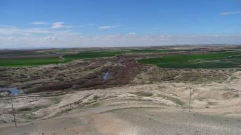
Negev desert geomorphology
 und fluvialen sowie äolischen Sediment-Archiven (Foto: J. Schmidt)")
Sedimentologische und geomorphologische Charakterisierung von fluvialen und äolischen Sedimentarchiven in der nördlichen Negev-Wüste
Die antike Stadt Elusa in der nördlichen Negev Wüste in Israel gilt als bedeutendes Zentrum für Weinexport in der Zeit vom 2. Jh. v. Chr. – 7. Jh. n. Chr. Die Region ist heute jedoch durch arides Klima geprägt und landwirtschaftliche Nutzung nur mittel Bewässerungsmethoden möglich. Die Art und Weise der Bewässerung ist für die Antike im Bereich Elusas noch unbekannt. Auch die Rekonstruktion antiker Klimabedingungen ist bisher nur in grober Auflösung vorhanden. Sedimentologische Archive aus den fluvialen (Wadis), äolischen (Dünen und Stäube) sowie kolluvialen (Hangablagerungen im direkten Umfeld der antiken Stadt) Systemen im Umfeld der Stadt bieten die Möglichkeit geomorphologische Dynamiken aus diesen Archiven heraus abzuleiten.
Im Rahmen eines Geländeaufenthalts wurden im Juli/August 2022 17 Sedimentprofile aufgenommen und 22 Sedimentproben entnommen. Im Rahmen der Abschlussarbeit sollen die Proben auf ihre Korngrößenverteilung hin im Labor untersucht werden. Eine systematische Zusammenstellung der Geländebefunde, der Laborergebnisse und einer Auswertung eine hochauflösenden Geländemodells ermöglicht eine Archivklassifikation und räumlichen Verbreitungskarte. Eine mögliche statistische Analyse der Korngrößenverteilungen (grain size endmember anaylsis) erlaubt zudem die Ausweisung von Prozess-endmembern und Entmischung von multi-Prozess Sedimentarchiven.
Ansprechpersonen: Johannes Schmidt, Christoph Zielhofer, Birgit Schneider