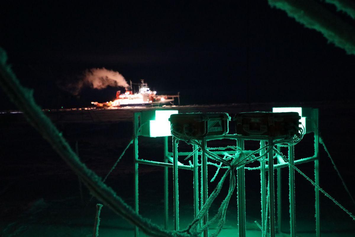
Clouds and precipitation are important components of the climate system, but their key processes are not sufficiently understood. In our research group, we develop innovative measurement techniques to characterize cloud and precipitation properties.
Research profile
The clouD and pRecipitation Observations for Process Studies (drOPS) research group is working on innovative methods to better measure precipitation and cloud properties using remote sensing and in-situ techniques.
The goal is to better understand and analyze the processes within clouds that are responsible for the formation of precipitation using improved measurements. Furthermore, it is investigated how clouds interact with external factors such as aerosols. Innovative measurement techniques are being developed that use machine learning methods to combine information from different measurement devices in order to characterize cloud and precipitation properties. For snowfall, remote sensing observations are combined with the specially developed Video In Situ Snowfall (VISSS) camera.
RESEARCH PRIORITIES
Current research priorities are:
- The characterization of the spatial variability of Arctic mixed-phase clouds; and
- A better understanding of the riming process.
Current Research Projects
The projects listed below are subprojects of joint projects funded by the German Research Foundation and projects for temorary positins funding by the German Research Foundation
Arctic Amplification: Climate Relevant Atmospheric and Surface Processes, And Feedback Mechanisms
Period: 01.01.2020 – 31.12.2023
Funding: German Research Foundation
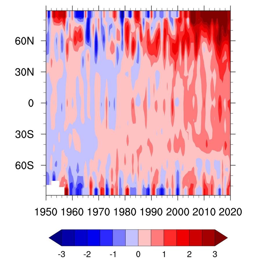
Planet earth has warmed on average by 0.87 K over the past 150 years. In the Arctic, the warming is much larger, which became most prominent over the last decades. Currently, the Arctic warming exceeds the increase of near-surface air temperature in the mid-latitudes by about 2 K. This phenomenon is commonly referred to as Arctic amplification.
Fusion of Radar Polarimetry and Numerical Atmospheric Modelling Towards an Improved Understanding of Cloud and Precipitation Processes
Funding: German Research Foundation
Wolken- und Niederschlagsprozesse sind seit Jahrzehnten die Hauptquelle von Unsicherheiten in der Wettervorhersage und in Projektionen zum Klimawandel. Ein Großteil dieser Unsicherheiten kann auf fehlende Beobachtungen zurückgeführt werden, die geeignet sind, die Darstellung von Wolken- und Niederschlagsprozessen in atmosphärischen Modellen zu hinterfragen. Die gesamte Atmosphäre über Deutschland wird seit kurzem von 17 hochmodernen polarimetrischen Doppler-Wetterradaren überwacht, die alle fünf Minuten 3D-Informationen über die flüssigen und gefrorenen Niederschlagsteilchen und deren Bewegungen mit einer Sub-Kilometer-Auflösung liefern, die auch von den Atmosphärenmodellen für Wettervorhersagen und Klimastudien herangezogen wird. Die Datenassimilation führt Beobachtungen und Modelle zur Zustandsschätzung als Voraussetzung für die Vorhersage zusammen und kann als intelligente Interpolation zwischen Beobachtungen betrachtet werden, wobei die physikalische Konsistenz der atmosphärischen Modelle als mathematische Randbedingung genutzt wird. Es bestehen jedoch erhebliche Wissenslücken sowohl in der Radarpolarimetrie als auch in den atmosphärischen Modellen, die die volle Ausnutzung des Dreiecks Radarpolarimetrie - atmosphärische Modelle - Datenassimilation behindern und eine koordinierte interdisziplinäre Anstrengung erfordern. Das Schwerpunktprogramm wird die Synergie der neuen Beobachtungen und modernster atmosphärischer Modelle nutzen, um feuchte Prozesse in der Atmosphäre besser zu verstehen und ihre Darstellung in Klima- und Wettervorhersagemodellen zu verbessern. Das Programm wird unser wissenschaftliches Verständnis an den Grenzen der drei Disziplinen für bessere Vorhersagen von niederschlagbringenden Wolkensystemen erweitern, indem es die folgenden Ziele anspricht.
Subproject: Characterisation of orographically influenced riming and secondary ice production and their effects on precipitation rates by radar polarimetry and Doppler spectra (CORSIPP)
Period: 01.01.2022 – 30.06.2025
Team: Veronika Ettrichrätz, Dr. Maximilian Maahn
The goal of the project "CORSIPP" in cooperation with the research group of Jun-Prof. Dr. Heike Kalesse-Los is to better understand the interaction of ice crystals and liquid supercooled cloud droplets. A special focus is put on the riming process and on secondary ice crystals, which can break off e.g. during the riming process.
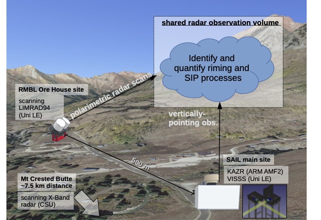
To obtain the necessary data, a 94 GHz cloud radar and a VISSS snowfall camera will be sent to Colorado in the winter of 2022/23 to participate in the international SAIL campaign.
Investigation of microphysical processes during the Snowfall Formation at Mid-Latitudes
Funding: German Research Foundation
Period: 01.06.2023 – 31.05.2026
Team: Nils Pfeifer, Dr. Maximilian Maahn
Precipitation is a major yet poorly understood component of our climate system. In a warming climate, it is expected that precipitation amounts and extreme events, including heavy snowfall are increasing (Quante et al. 2021), but the exact magnitudes are associated with large uncertainties (Lopez-Cantu et al. 2020). This is because the pathways through which ice crystals, liquid water, cloud dynamics, and aerosol particles are interacting during precipitation formation are not well understood leading to gaps in the representation of these processes in numerical models. This lack of process understanding also limits insights into cloud evolution processes, because snowfall removes water from the atmosphere.
Objectives
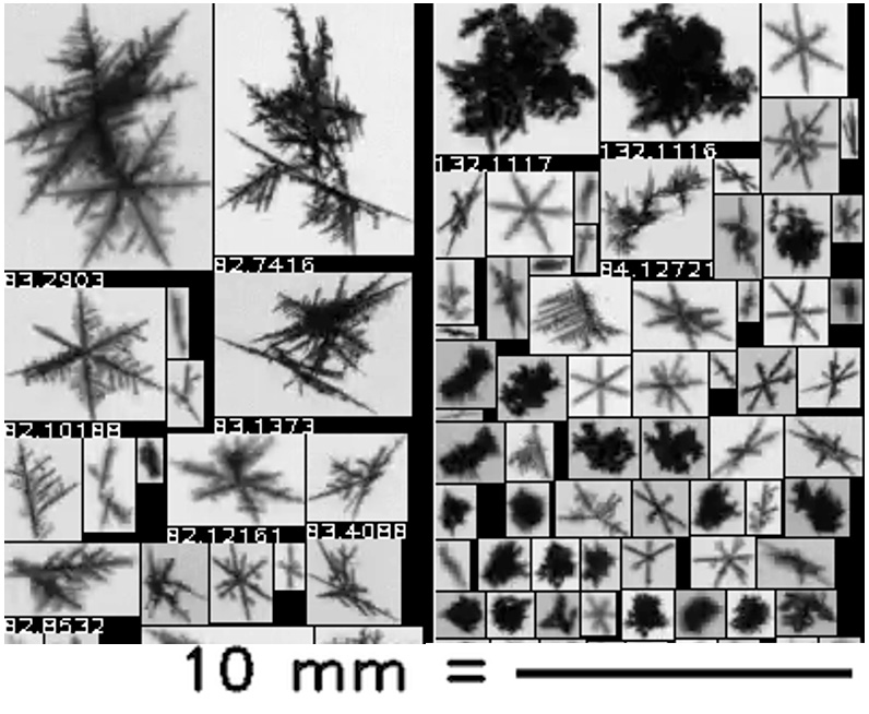
The goal of the EMPOS project is to enhance our understanding of microphysical pathways during snowfall formation by combining novel in situ snowfall observations with sophisticated modeling tools. We hypothesize that this can be achieved by comparing observed contributions of riming, aggregation and depositional growth to snowfall mass and frequency with atmospheric models. Targeting individual processes will ensure that identified biases in the model can be attributed to individual snowfall formation pathways and the model can be improved where it is most relevant.
Specifically, the main scientific objectives of this project are:
- Objective S1: to quantify how riming, aggregation, and depositional growth processes are involved in snowfall formation in terms of frequency of occurrence and total snow mass.
- Objective S2: to understand these cloud processes as a function of macrophysical cloud properties such as cloud depth and synoptic forcing.
To accomplish the scientific objectives, we will pursue the following technical objectives:
- Objective T1: Quantify riming and aggregation processes from VISSS measurements.
- Objective T2: Evaluate and improve snowfall simulation in ICON in the standard twomoment scheme and in the P3 microphysical scheme
SIGnificance of secoNdary ice to Arctic snowfall
Funding: Humboldt Foundation
Period: 01/08/23 – 31/07/24
Team: Dr. Haoran Li
The research focuses on quantifying the microphysical processes in clouds and precipitation with remote sensing instruments. A synergy of remote sensing and surface observations will be used to quantify the impact of secondary ice processes on Arctic snowfall. Novel algorithms for ice number concentration retrievals will be used to quantify the contribution of secondary ice to surface snowfall accumulation. This project is expected to deepen our understanding on how cloud microphysical processes influence the snowfall over the rapidly warming Arctic.
Finished Research Projects
The projects listed below are subprojects of joint projects funded by the German Research Foundation and projects for temorary positins funding by the German Research Foundation
Arctic Amplification: Climate Relevant Atmospheric and Surface Processes, And Feedback Mechanisms
Period: 01.01.2020 – 31.12.2023
Funding: German Research Foundation
Planet earth has warmed on average by 0.87 K over the past 150 years. In the Arctic, the warming is much larger, which became most prominent over the last decades. Currently, the Arctic warming exceeds the increase of near-surface air temperature in the mid-latitudes by about 2 K. This phenomenon is commonly referred to as Arctic amplification.
Instrumentation
The Video In Situ SNowfall Sensor (VISSS) is an optical instrument developed in the drOPS group that can be used to determine the size, shape and fall speed of snowflakes.
The VISSS has a fairly large, free-standing observation volume, allowing a large number of snowflakes to be measured at high optical and temporal resolution without disturbing the wind field. The first VISSS was built specifically for MOSAiC, and an improved version was deployed in Ny-Ålesund in 2021.
Campaigns:
| CORSIPP contribution zu SAIL (Surface Atmosphere Integrated Field Laboratory) | Gothic, Colorado, | 2022/23 |
| (AC)3 SYNCLOUD (Synergistic long-term observations of vertically resolved cloud properties using a novel microwave radiometer/radar for Arctic) | Ny-Ålesund Norway | since 2021 |
| CRIOS (Combining Radar and Imagining Observations for Snowfall measurements) | Hyytiälä Finnland, | 2021/22 |
MOSAiC (Multidisciplinary drifting Observatory for the Study of Arctic Climate) | Arctic sea | 2019/20 |
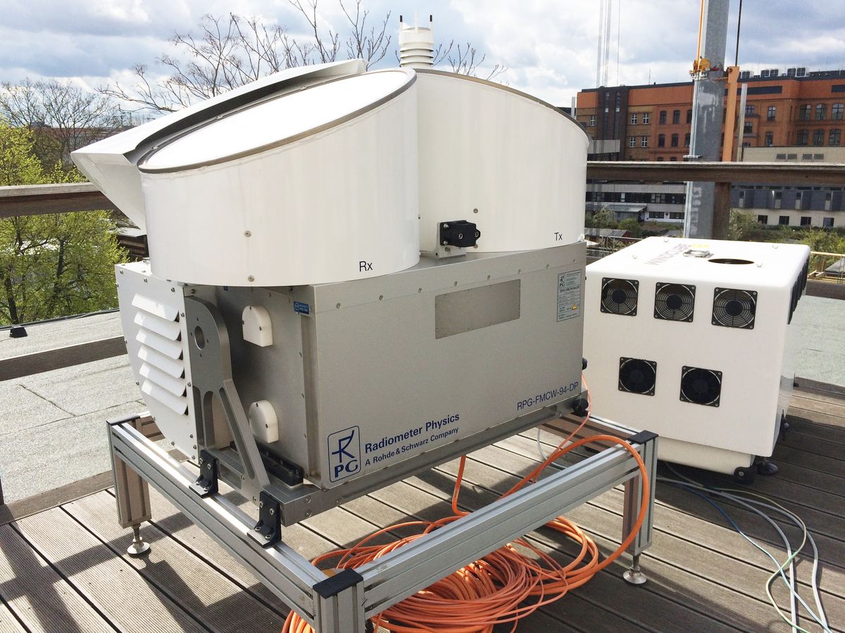
Manufacturer: Radiometer Physics GmbH
Centre Frequency: 94 GHz (λ=3.19 mm) ± 100 MHz typical
IF range: 0.35 to 4.5 MHz
This radar was developed for atmospheric research. It operates at 3.2 millimeter wavelength which allows for reaching high sensitivity with small sizes of the instrument. The radar provides range profiles of parameters that contain information about scatterers in the atmosphere such as cloud particles, raindrops, snowflakes and insects. The radar utilizes frequency modulated continuous wave (FMCW) signals and therefore has high range resolution down to 1 m. Doppler and polarimetric (optional) capabilities of the radar make a good basis for a classification of particles and a quantitative characterization of hydrometeors.
Areas of Applications
- Calibration of precipitation and cloud radars including satellite-based systems
- Estimation of propagation effects for satellite links
- Precipitation and fog nowcast
- Hydrometeor classification
- Quantitative precipitation estimation
- Wind direction and speed retrieval
- Profiling of liquid water
- Microphysical analysis of clouds and precipitation
Campaigns:
| CORSIPP contribution zu SAIL (Surface Atmosphere Integrated Field Laboratory) | Gothic, Colorado, | 2022/2023 |
| HALO-(AC)3 | Svalbard, Norway | Spring 2022 |
